
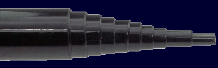
The 'Heavy Duty' fibreglass pole in reinforced version
Manufacturing details
It is a 'Heavy Duty' fibreglass pole in reinforced version with a weight of 1.7 kg.
The diameter of the top tube is approx. 11 mm at the top and approx. 45.8 mm at the bottom.
The wall thickness is approx. 1mm at the top and approx. 2mm at the bottom.
The HD fiberglass mast consists of a total of 10 segments. In the case of this antenna only 7 segments are used. There is a bottom plug which is flush and glued in place with the bottom tube. This part was taken away in order to be able to select the tubes of the pole needed to have the perfect length for the antenna.
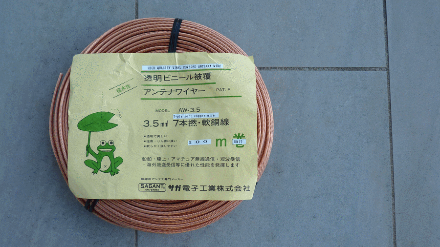
A special transparent high quality vinyl covered 3.5 square millimeter copper antenna wire of 5.28 meters in length is slept inside the fibreglass pole.
{Back to top}
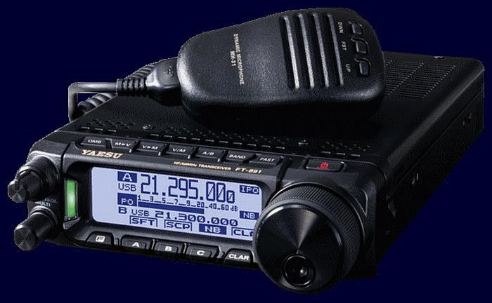
The new exciting Yaesu FT-891 HF/50MHz 100W all mode transceiver. It is the smallest with these features in the world.
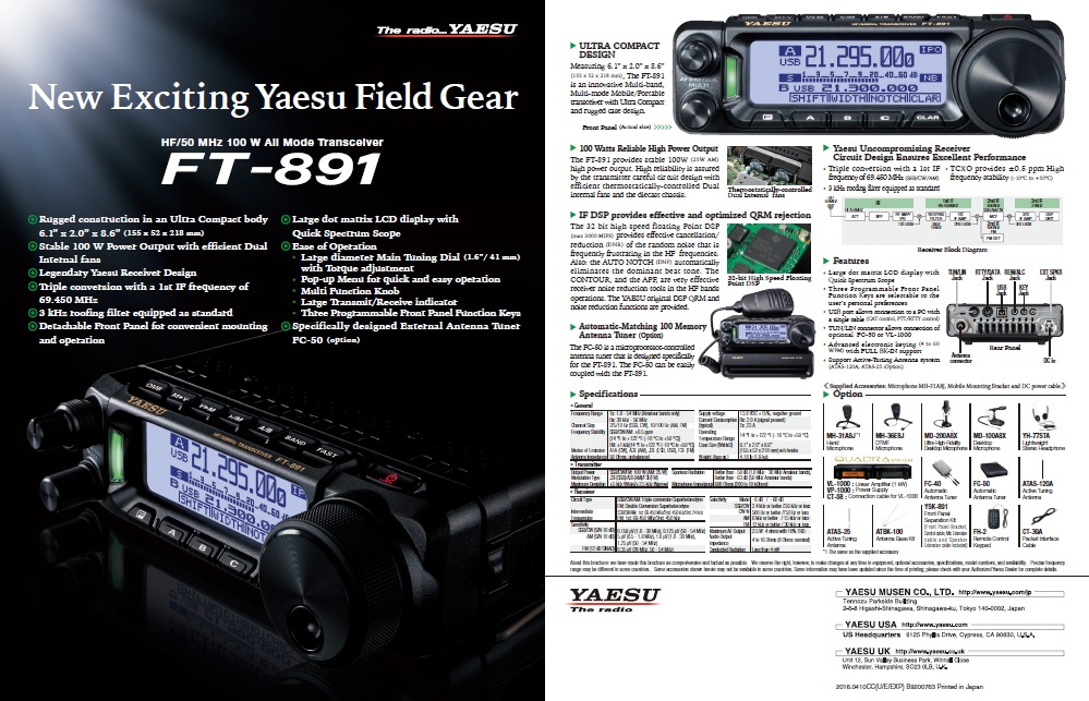
Click the image above to read or to download the brochure (.pdf file) in a new tab or window.
Yaesu FT-891 Quick Manual (EN)
Yaesu FT-891 Operating Manual (EN)
Yaesu FT-891 Advance Manual (EN)
Yaesu FT-891 Service Manual (EN)
* * *
Yaesu FT-891 Manuel d'utilisation (FR)
Yaesu FT-891 Manuel avancé (FR)
{Back to top}
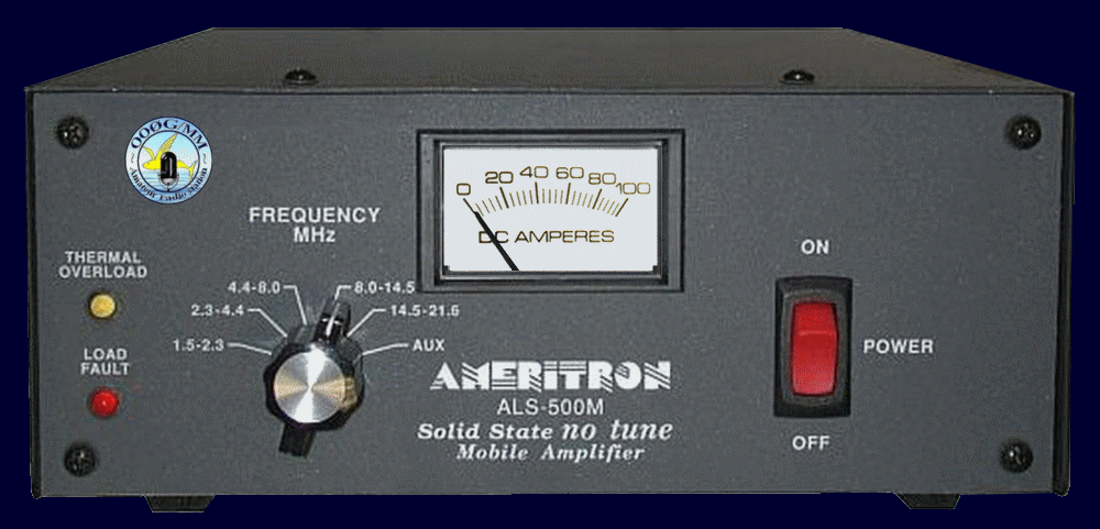
The Ameritron ALS-500M is a 500W PEP output solid state no tune linear amplifier operating at full power with continuous frequency coverage from 1.5 through 30 MHz.
Ameritron ALS-500M unique early model instruction manual restored by 00ØG
About this manual
In the original manual of the early models the schematics were poorly reproduced. As a result it was quite difficult to read them and in some places to see where the connections led. For this reason, the schematics have been restored in order to have a manual with clear and reliable schematics in case of need. This manual is unique and is the property of the station ON6WG/F5VIF/OOØG and its operator who alone decides on its use. It is made available by the station. Anyone can consult it or download it for strictly personal use. It cannot be redistributed or shared or spread on the web. See "Terms of Use for the ON6WG/F5VIF Website" in the "Copyright" section.
{Back to top}
On the boat the main mode used to contact other stations is SSB mode. There are two reasons for this. First, when I am at home at the radio station, to avoid local QRM I mainly use CW to contact other stations. So the boat is a good opportunity to use SSB telephony mode. Second, depending on the sea state, the boat can be unstable, sometimes pitching and rolling accompanied by some hard knocks which makes it difficult to use the Morse key correctly. When sailing, there will be too many "bugs" to send a correct and clean message.
{Back to top}
Notwithstanding the foregoing considerations, there is the necessary equipment on board to transmit in CW. Sometimes when the boat is moored in a quiet place or in a harbour, OOØG/MM is using the CW mode for practice and because it is the preferred mode of the operator. In case of bad wave propagation when the signals are too weak and impossible to understand in SSB, the CW mode can be used and helps a lot.
{Back to top}
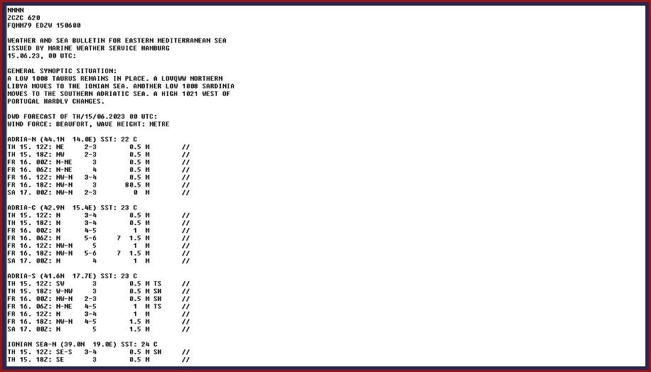
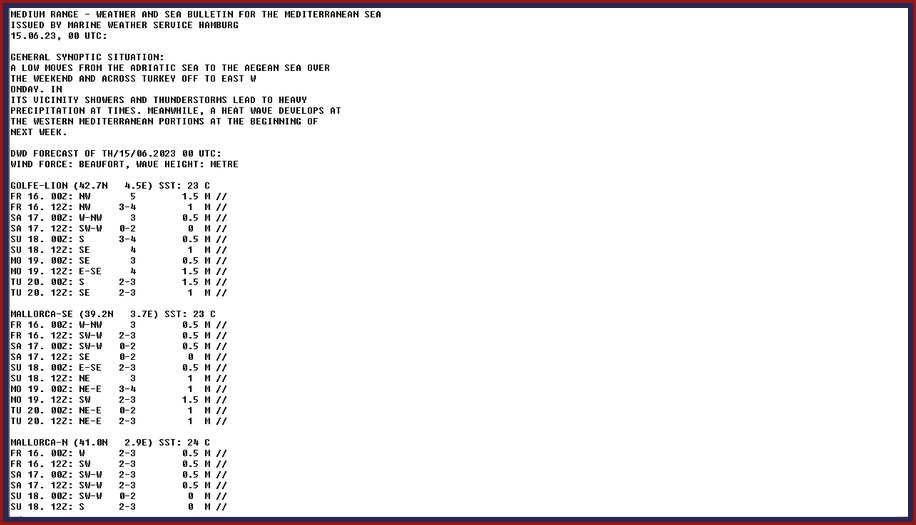
RTTY is mainly used to receive marine weather forecast.
At sea, far off the coast there is no longer an internet connection. The weather reports transmitted by stations on VHF channels are not very detailed. The voices (synthetic or from an operator) transmitting the reports are not always clear,
the English pronunciation is sometimes very approximate, and let's not talk about reports transmitted in a foreign language that we do not understand. In addition, the VHF waves are only received a short distance from the coasts. To overcome these
inconveniences, aboard S/V Petit Prince 2, the reception of the meteorological bulletins intended for navigation in the Mediterranean Sea can also be done through shortwave radio. The radioteletype DDK9 station located in northern Germany is continuously
broadcasting a weather bulletin covering the European seas and the North Atlantic. The bulletin for the Mediterranean Sea is divided into detailed specific areas. Furthermore, the frequency of DDK9 is just at the lower limit of the 30-meter
amateur radio band. The onboard vertical antenna, which can operate on this band, is therefore perfectly suited to receiving maritime weather bulletins in the best conditions. The signals are generally very strong in the Mediterranean Sea.
JVComm32 or MMTTY computer programs are used for decoding. Another advantage of this system is that bulletins can be stored in memory to be read again later. When MMTTY is used, OOØG/MM is also able to transmit in RTTY.
In the "Videos" section of the drop-down menu at the top of this page you will find two short videos titled "Receiving DDK9" and showing the reception of a weather report while sailing.
{Back to top}
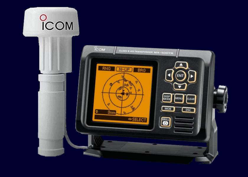
The ICOM MA-500TR AIS transponder and its GPS antenna used on board the boat.
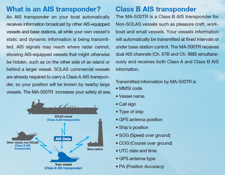
To transmit information the transponder is connected to the antenna used by the marine VHF transmitter through an automatic antenna splitter. So only one VHF antenna placed at the top of the mast is needed. It is also thanks to this transponder that we can follow the movements of the boat in real time on the web. The information received by land stations is also transmitted to specialized websites which can then show the boat's position on a map. Since VHF waves have a short range, transponder signals are also received by a network of satellites , which makes it possible to position a boat even in the middle of an ocean. You can follow S/V Petit Prince 2 and OOØG/MM live by going to the “Position (live)” section of the drop-down menu at the top of this page. Note: When the boat is out of VHF range of land stations the position will no longer be shown on the maps of specialized websites because they require a subscription to display the positions given by the satellites.
{Back to top}
A new QSL card is released every sailing season. Of course if the boat is not sailing then the OOØG/MM station will not be able to transmit and therefore there will be no new edition of QSL card. These QSL cards are collectors' items. The card is sent automatically to all the stations contacted. No response is required. Obviously a response will be very much appreciated and the cards received in response will be added to the list displayed on the OOØG/MM station web page to illustrate the performance of the station and its antenna and also to highlight the stations contacted. QSL cards from previous seasons are visible from the horizontal drop-down menu bar "Radio Station" section or from the "Site Map" vertical menu. Received QSL cards are visible from the horizontal drop-down menu bar "Slideshows" section or in the "Site Map" vertical menu under "QSL cards received".
{Back to top}
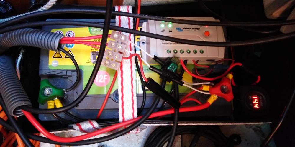
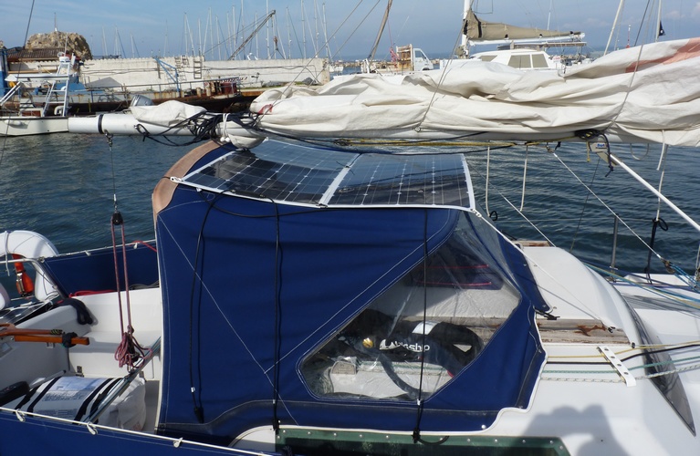
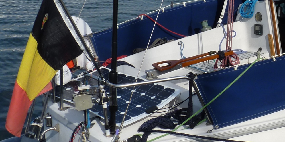
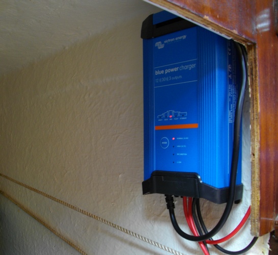
Electrical energy is an essential part for the proper functioning of the boat. First it is necessary for the operation of the autopilot which has a dedicated 70 amp battery. Two other 70 amp batteries are used for the general power supply of the boat (navigation lights, cabin lighting, navigation tablet, AIS system, marine VHF transmitter, charging the phone or other devices, ice maker, small compressor fridge, transceiver and HF amplifier of the OOØG/MM station). These two batteries can be connected in parallel, isolated from each other or switched off by means of a special switch. In transmission with the 500W amplifier the station uses approximately 100 Amps. At sea the battery charge is maintained by three solar panels each delivering approximately 100W. Each solar panel is connected to separate battery. This way is sufficient to maintain the charge level in each battery. Each battery has its own electronic charge regulator and a digital voltmeter. In a harbour or a marina the battery charge level is maintained by a 30 Amp electronic charger with three outputs. This charger operates automatically or is also programmable.
{Back to top}
This section concerns the use of a prefix and a suffix /MM, /M or /P in the call sign of an amateur radio station located on board a vessel. A slideshow is also illustrating the discussion.
Prerequisites to understand the following argumentation :
An officially registered vessel is governed by the laws and regulations of its flag. This vessel is considered a small piece of the territory of its flag. When a foreign vessel is authorized to enter inland waters, it is subject to the laws of the coastal state, with one exception:
the crew of the ship and the internal rules governing the vessel remain subject to the law of the flag state. Therefore... as the vessel is subject to the laws of the coastal state a transmitting station located on board is prohibited from transmitting when in the inland waters of this coastal state.
However, in the European Union, the request for pratique (authorization to enter and move within inland waters) is removed for member countries of the Union. In addition, most member countries have signed the CEPT agreements with reciprocity. A mobile amateur radio station can move from one country to another and transmit simply by adding the prefix of the country where it is located in front of its call sign without any other form of allowance. Therefore, in the Union, since the border rules are greatly relaxed, it could be considered that an amateur radio station on board a foreign ship that is also a member of the Union could be authorized to transmit in territorial waters of a land other than its own flag.
Prefix :
For the amateur radio station this means that in the territorial waters and inland waters of a foreign country the call sign must be preceded by the prefix of that country.
Suffix /M ? or /MM ? :
Here things get complicated. In view of the new regulations that are appearing, we should first answer this question : In this country is the suffix mandatory or is it optional ? And next, which one to use ?
In territorial waters and inland waters, the suffix /MM or /M may be used. There is however an important difference for the stations contacted. Indeed with the suffix /MM a QSO will not be valid for the DXCC while with the suffix /M this same QSO will be valid. The regulations do not specify what /M stands for simply because this suffix encompasses all possibilities of movement (e.g. a station can be moving in a soapbox as well as on a walking pedestrian). The /M suffix therefore also applies to a boat.
Note on the /M suffix and inland waters
Merriam-Webster dictionary definition of "inland waters" of a country.
inland water (noun)
1: any of the waters (as lakes, canals, rivers, watercourses, inlets, and bays) within the territory of a state as contrasted with the open seas or marginal waters bordering another state subject to various sovereign rights of the bordering state.
2: water of the interior that does not border upon marginal or high seas or is above the rise and fall of the tides.
According to the United Nations Convention on the Law of the Sea, a nation's internal waters include waters on the side of the baseline of a nation's territorial waters that is facing toward the land. It includes waterways such as rivers and canals, and sometimes the water within small bays. (Wikipedia)
In conclusion, if the boat is moving along a coast, in a bay, a cove, an inlet it can use the suffix /M.
Now let's look at the DXCC Rule 8
"8. All stations contacted must be “land stations”. Contacts with ships and boats, anchored or underway, and airborne aircraft, cannot be counted. For the purposes of this award, remote control operating points must also be land based. Exception: Permanently docked exhibition ships, such as the Queen Mary and other historic ships will be considered land based."
/M stations are never asked to prove that they are land based when submitting a QSO to the DXCC simply due most likely to a misunderstanding of the /M meaning. Therefore...
Suffix /P ? :
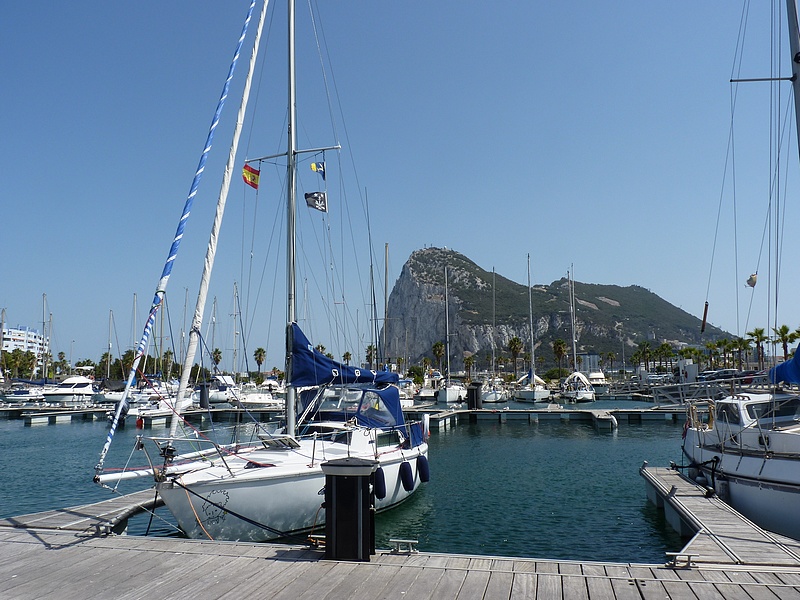
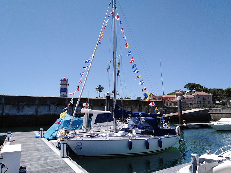
When a boat is moored at a marina dock or a quay it should not use /M or /MM since it is not moving. In addition it is very likely that the boat is either connected to the AC power terminal of the dock. In this case the suffix to use should be /P.
Explanatory comments about the slideshow images
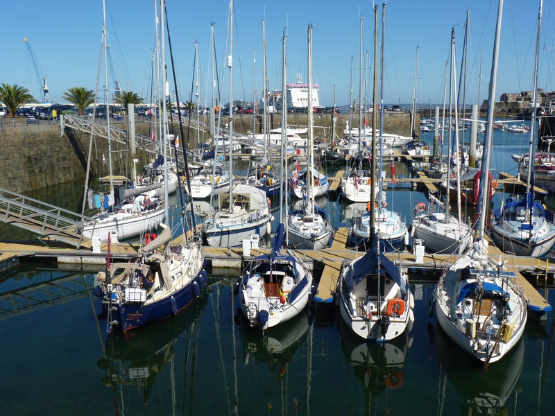
Image 1 :
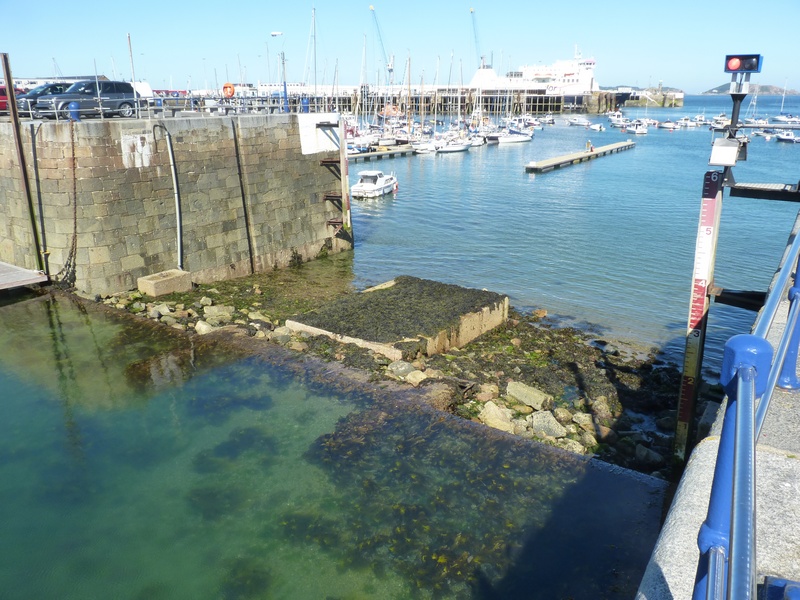
The S/V Petit Prince 2 (OOØG/MM, 2nd in the foreground from the left) is moored at a pontoon in the inner marina of St.Peter Harbour Guernsey. The boat is connected to an electricity terminal on the pontoon. It should be noted that this basin is surrounded by a thick stone wall and that it is well set back from the outer harbour where one can glimpse the old fort built on a rocky outcrop. We can also clearly see the entrance (or exit, depending) to the basin. We can also see that the basin is much higher than the outer harbor and that the tide is low.
Image 2 :
Central image of the basin. We can clearly see the access and the transparency of the water. The shallow depth allows us to see the bottom (approx. 3m). Here too we can clearly see the difference in level between the outer harbour and the small inner basin of the marina. We are also in a region where the tidal range is among the largest in the world.
Image 3 :
The access opening to the basin.
Image 4 :
Access to the basin is via a step preventing a certain level of water from leaving the basin at low tide.
So we are in a closed water basin built on a rock of the island and isolated at low tide. Moreover the boat is moored to a pontoon and connected to land electricity. The entrance of the basin is dried at low tide. Therefore the boat must be considered land based. The /P suffix applies well in this case.
/P stations are never asked to prove that they are land based when submitting a QSO to the DXCC. Therefore...
Note on the suffix /P in inland waters
The suffix /P must also be used when the boat is moored on a buoy or at anchor in a river or an inlet because even if it can turn around the buoy or its anchor because of the wind or the current the boat is considered to be stationary. The suffix /P must also be used when the boat is pulled ashore.
Conclusion
If during its peregrinations S/V Petit Prince 2 and the OOØG/MM station reach rare IOTA islands or interesting DXCC prefixes and the conditions are met, the use of a suffix allowing the validation of QSOs for the DXCC will be used (most likely /P). This has already been the case during the station's stopover in Guernsey and Jersey with the call signs GU/OOØG/P and GJ/OOØG/P respectively. LoTW certificates were obtained before departure.
{Back to top}
Perhaps you want to see the boat sailing at sea or what sometimes happens around it. So just take a look at these videos
* * * * * * * * * * * *